White Rock - British Columbia
Photo © Judy MacDonald. Used with permission. |
|
|
|
|
 |
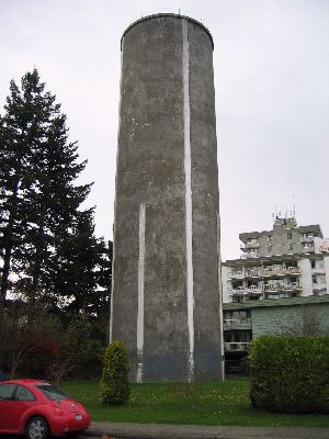
Standpipe information: (5-2010)
Built: 1963. Height 32 meterst. Capacity: 2,588,180 liters |
White Rock
is a seaside community, 45 km's from Vancouver and five minutes from the Canada/USA border. It borders Semiahmoo Bay and is surrounded on three sides by South Surrey. To the southeast across a footbridge lies the Semiahmoo First Nation, which is within the borders of Surrey. Semiahmoo Bay and the Southern Gulf Islands in the Strait of Georgia are also to the south.
- The modern history of White Rock is directly tied to the railway linking British Columbia to Washington state, which runs along the shore of Semiahmoo Bay to the border. The rail is currently owned by BNSF Railway and runs alongside the promenade at the beach. This was originally the Great Northern line, and it opened up White Rock and Crescent Beach to tourists from Vancouver and New Westminster in the early 1900s. The border crossing closest to White Rock (at Douglas, B.C., and Blaine, Washington) was officially opened in 1908, and the Peace Arch at the border crossing was constructed in the 1920s. In 1913, the present railway station was openedThe Campbell River Mill opened to the east, bringing a minor boom in the local economy. The now-famous pier was opened in 1914 to provide a deep-water mooring facility. Wikipedia |
Other sites you may be interested in:
Thumbnail Collection of USA Water Towers
USA Water Towers and Standpipes
Magnetic Hills: CA, USA, Worldwide
The History of the Christian Fish Symbol |
|
|
| Home |
 |
BC W index |
|